Earthquakes are a risk to people and infrastructure in Canada. While damaging earthquakes don’t happen often, the impacts will be significant when one inevitably occurs, especially if it is centered near a densely populated area. Strong ground shaking from earthquakes can impact many things we care about and rely on. It can injure people, disrupt businesses, damage infrastructure, destabilize and liquify ground, trigger a tsunami, or spark fires in damaged buildings. If communities aren’t prepared for the impacts that could occur, they may not have the capacity to withstand and recover. Earthquake scenarios help understand the potential impacts of earthquakes and prepare for them.
An earthquake is an episode of ground shaking that happens when there is a sudden stress release in the earth’s crust. Earthquakes happen along faults – places where blocks of the earth’s crust move against each other. Seismologists and earth scientists at Natural Resources Canada (NRCan) examine earthquake activity and evidence of past earthquakes in geologic and historical records to identify areas where earthquakes might happen in Canada. You can learn more about NRCan’s work and understanding of earthquake hazards in Canada here and more general information from Public Safety Canada here.
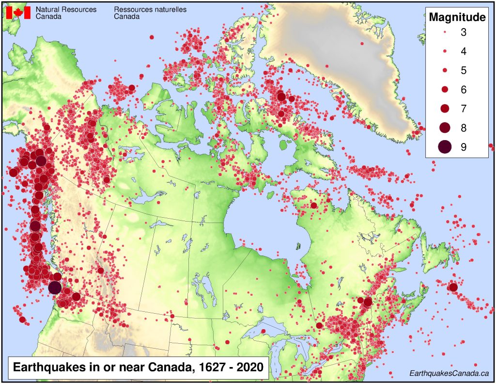
Many Indigenous peoples’ oral traditions and histories tell of earthquakes and tsunamis and their impacts. A map of earthquakes which have been recorded through seismographs or estimated between 1627 to 2020 is shown below.
Earthquake risk can be understood by examining the impact of specific scenarios as well as considering the likelihood of damage through a probabilistic approach. RiskProfiler provides seismic risk estimates for both specific earthquake scenarios as well as over annual or 50 year (return) periods from a probabilistic estimate of all possible earthquakes.
Risk results from a combination of hazard, exposure, and vulnerability. The figure below is a depiction of risk.
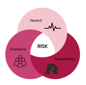
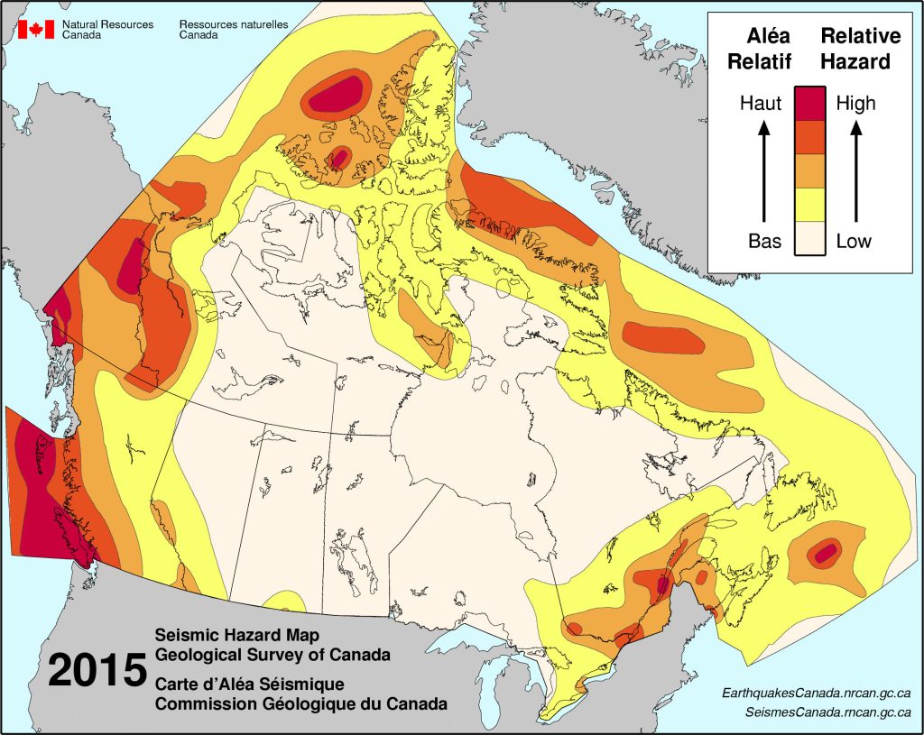
Hazard is the anticipated level of ground shaking from earthquakes. Hazard varies from place to place, and is generally higher in zones that are seismically active such as the west coast, Yukon, and St Lawrence river areas as shown on the map below.
Exposure is the assets that may be affected by the shaking. In RiskProfiler the exposure of buildings, building contents, and people to earthquakes are estimated. Vulnerability describes the potential to suffer some level of damage or loss depending on the severity of the earthquake ground shaking. It is based on attributes such as building construction, seismic resilience or social vulnerability.
When you combine our understanding of hazard, exposure, and vulnerability, you get risk. Two identical communities with the same hazard might have very different risks if one community has buildings that can be more easily damaged by shaking. For example, historical brick buildings tend to be more easily damaged by earthquakes relative to wooden buildings. Although we cannot change our underlying hazard, we can develop strategies to reduce the potential exposure and vulnerability to manage the risk. Information provided on RiskProfiler is designed to help users work towards this goal.
Some risk models may also consider capacity and additional impacts such as disruption, infrastructure damage, displacement, and subsequent hazards, however, those are not considered in RiskProfiler at this point. See the FAQ for more information on the risk estimates and the Learn More section on Uncertainties and Intended Use.

An earthquake scenario describes a potential earthquake and its consequences. Scenarios are defined by a magnitude, location, fault type, and are developed for specific faults that can produce large earthquakes.
When multiple earthquake scenarios are combined, the result is called probabilistic earthquake risk. Probabilistic earthquake risk represents the potential consequences of all earthquakes that may occur over a defined time period from known earthquake sources. For example, probabilistic earthquake risk analysis can estimate the average annual economic losses from earthquakes or the economic loss expected to occur about once every 500 years.


Probabilistic seismic risk considers the impact of all possible earthquakes, over a time period of interest. To explore the risk in your area, please select an indicator below.