As we cannot yet predict an earthquake event, scenarios are developed to represent potential damage and losses from possible earthquakes. Scenarios are a tool to understand the impact of an earthquake on a community and provide information for planning and preparation.
An earthquake scenario has a specific magnitude, location, and source fault. Scenarios are developed for known faults, historical earthquakes, or regions where we know earthquakes can happen. The scenarios in RiskProfiler have been identified by NRCan analysts based on our best understanding of earthquake science, but there are many other earthquakes that could occur and these are not necessarily the largest or most damaging possible events. The scenario catalogue is a living database that will be updated as new information and planning needs are identified. You can find more information about the earthquake scenario catalogue here.
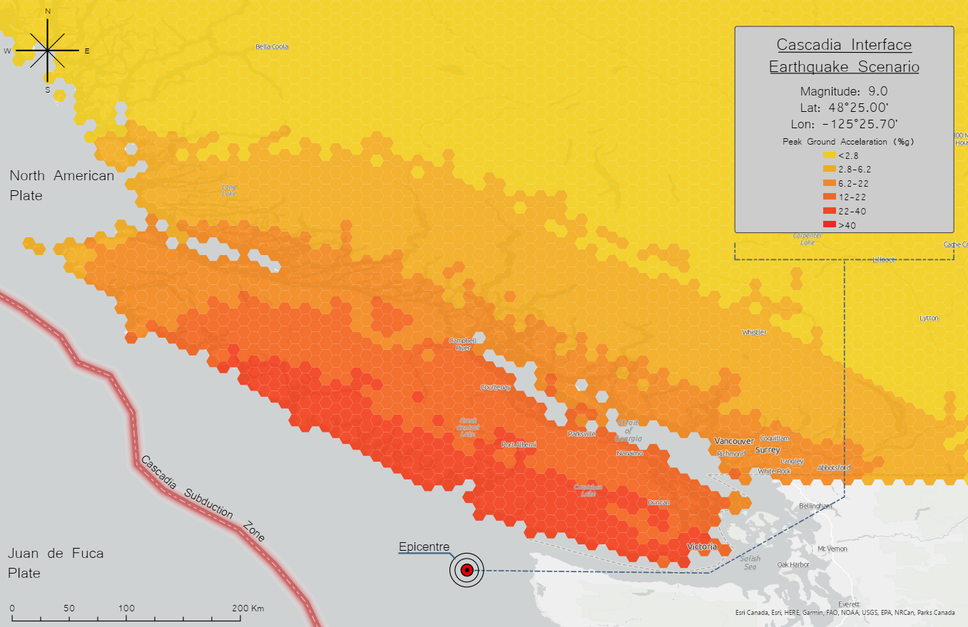
The impacts of an earthquake scenario are modelled by predicting the potential earthquake ground shaking for the scenario, the associated damage to buildings, and consequences as a result of building damage such as human casualties or financial losses. In general, places with more ground shaking, denser development, and fragile buildings (e.g. those made of brick as opposed to reinforced concrete) are more impacted than regions without. A detailed description of how NRCan estimates the impacts associated from earthquake scenarios can be found here. The uncertainties and intended uses of this information can be found here.
RiskProfiler provides the number of injuries and fatalities, direct economic cost, and number of buildings at each damage level within the earthquake impact area. RiskProfiler also provides information about the secondary consequence of how much debris may be generated from damaged buildings. For each area, you can explore how these estimates change by factors such as occupancy type, construction type, or seismic-design level. For example, it is generally true that there are more negative impacts from older pre-code buildings — buildings which were constructed prior to the acceptance of a stringent building code in Canada.
Earthquake information is available at the scale of ‘settled areas’, which show areas of building development at the scale of roughly a neighbourhood. See more information in the FAQ.
Information given for earthquake scenarios on RiskProfiler can help you answer questions like:
RiskProfiler also provides the same outputs assuming the entire building stock is seismically retrofitted. This can help answer questions such as: what is the total potential reduction in impacts if every applicable building in the current stock was retrofitted? When the results with the retrofit toggle are broken down by building type, then you can answer questions like: what building types should be retrofitted to achieve the largest reduction in impacts?

An earthquake scenario describes a potential earthquake and its consequences. Scenarios are defined by a magnitude, location, fault type, and are developed for specific faults that can produce large earthquakes.
When multiple earthquake scenarios are combined, the result is called probabilistic earthquake risk. Probabilistic earthquake risk represents the potential consequences of all earthquakes that may occur over a defined time period from known earthquake sources. For example, probabilistic earthquake risk analysis can estimate the average annual economic losses from earthquakes or the economic loss expected to occur about once every 500 years.


Probabilistic seismic risk considers the impact of all possible earthquakes, over a time period of interest. To explore the risk in your area, please select an indicator below.